What Is Ancient Earth Globe?
The Ancient Earth Globe is a unique interactive tool that shows how Earth looked at different times, from 750 million years ago to the present. You can use it to travel back in time and see the evolutionary changes in our planet, like when the first plants or dinosaurs appeared.
Developed by Ian Webster and hosted on DinosaurPictures.org, it features paleogeographic maps by C.R. Scotese of the PALEOMAP Project and combines scientific data with digital technology to present a dynamic view of Earth’s past.
It highlights significant events like the formation of the first coral reefs, the emergence of various life forms, and the creation of huge landmasses like Pannotia and Pangea. The maps are pretty accurate, up to about 100 km, and use colors to show different land heights and water depths.
Origin and Development of Ancient Earth Globe
The Ancient Earth Globe, created by former Google engineer Ian Webster in July 2015, is an innovative tool designed to make understanding Earth’s geological history both accessible and engaging. Using Christopher Scotese’s geological models, which map the Earth’s plate tectonic movements over 750 million years, Webster’s application provides a detailed view of our planet’s evolution since the time green algae first appeared in the oceans.
This interactive web application also integrates GPlates software, commonly used in geology, to visualize plate tectonic shifts. A standout feature of this tool is its ability to personalize the experience: users can enter their current location and see its place in historical geological contexts, like where New York City was during the era of the Pangea supercontinent.
This function effectively connects users to the ancient past of their own locales, enhancing the learning experience.
Ancient Earth Globe Examples
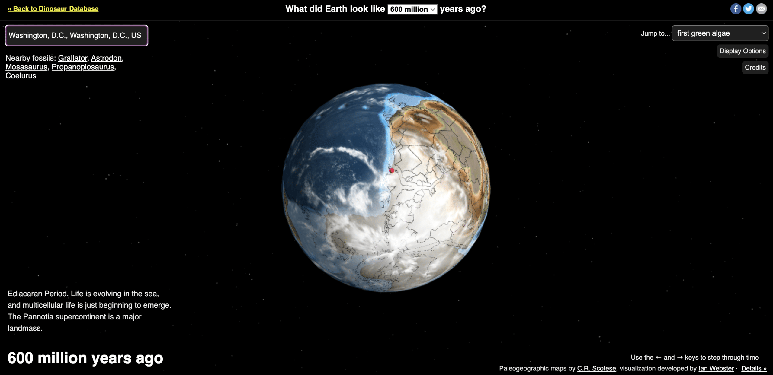
The Ancient Earth Globe on DinosaurPictures.org shows us how places like Washington, D.C., looked millions of years ago. For example, 600 million years back, during the Ediacaran Period, Washington D.C. was at the edge of a huge, icy continent next to an ocean. It was a completely different world from today.
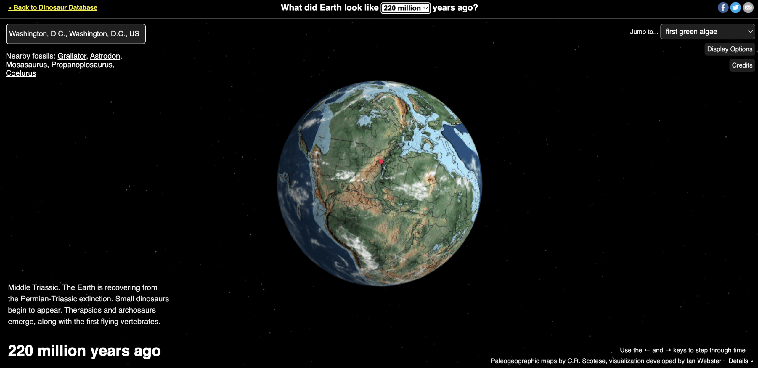
Jump to 220 million years ago, in the Middle Triassic Period, when Washington D.C. was far from any ocean and surrounded by land that would become Western Sahara and Mauritania. This was the time when the first dinosaurs appeared.
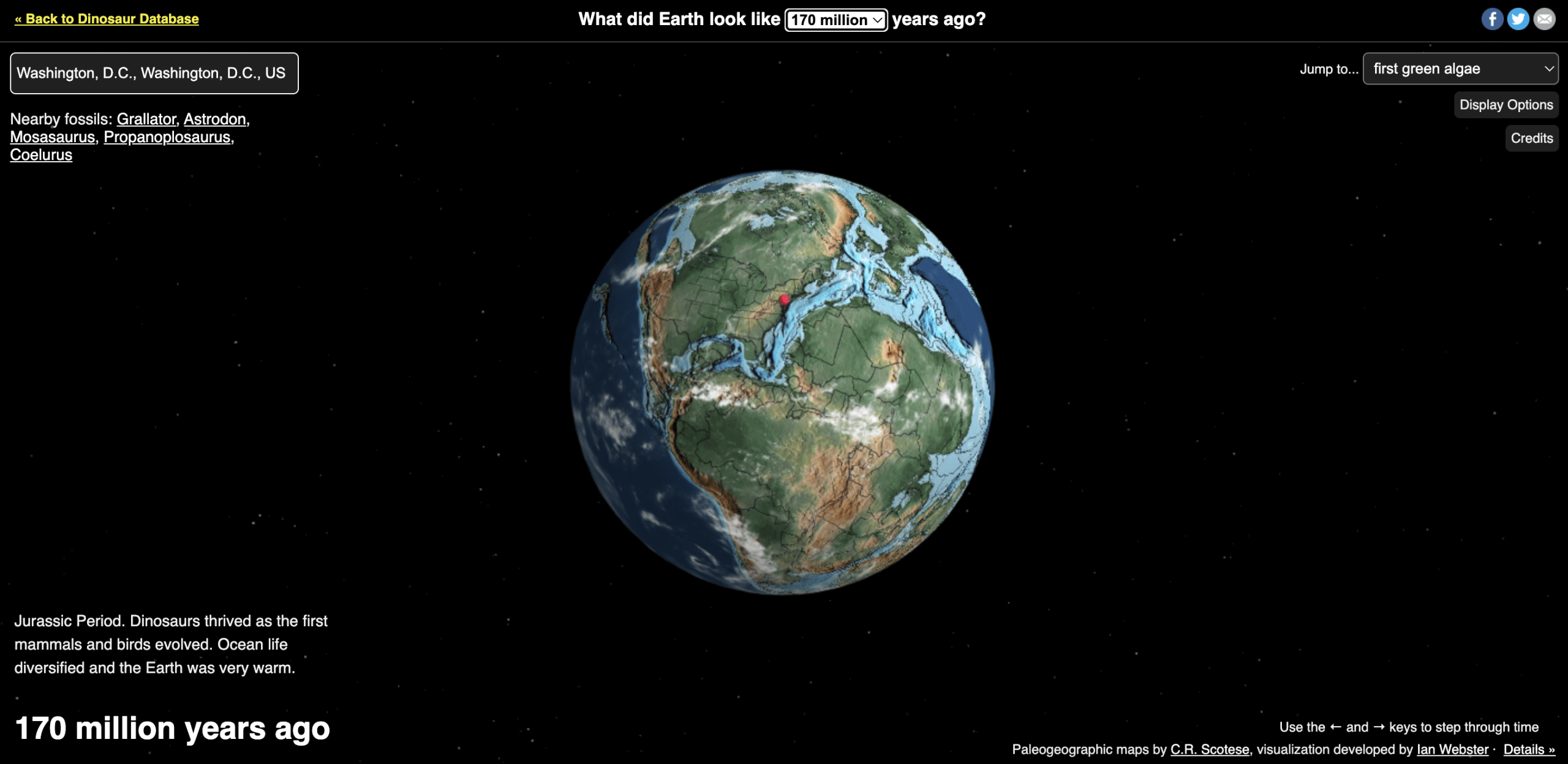
Then, around 170 million years ago, in the Jurassic Period, Washington D.C. split away from Africa, with a new ocean forming between them.
This period was famous for dinosaurs such as:
- The Astrodon: A majestic sauropod, the Astrodon roamed this area, its long neck and massive size a common sight.
- The Mosasaurus: In the seas, the formidable Mosasaurus, an enormous marine reptile, dominated, hinting at a rich and diverse marine ecosystem.
Challenges and Limitations of Ancient Earth Globe
The Ancient Earth Globe is a remarkable tool for learning about Earth’s history, but it comes with its own set of challenges and limitations. One significant challenge is ensuring the information about Earth’s changes over millions of years is accurate. Even though the globe uses our best geological and paleogeographic models, they’re still just estimates.
Another thing is the detail of the maps. They’re accurate up to about 100 km, but this means we might not see the smaller details in some places. This is fine for a general idea but might not be enough for those who want to dive deeper into certain areas.
Lastly, the visualization does not adjust the clouds and stars for time. This means that while it shows how Earth’s land and plates have moved over time, other natural elements remain static. This gives an incomplete view of Earth’s past environments.
The Bottom Line
The Ancient Earth Globe, available on DinosaurPictures.org, provides a distinctive perspective on how the Earth has changed over the past 750 million years.
Developed by Ian Webster, this tool combines scientific insights and modern technology to illustrate key moments in Earth’s geological and biological history.
It is a valuable educational resource, simplifying complex geological concepts, making them accessible to a wider audience, and maintaining a commitment to educational integrity.